Ricardo Viera:Your work has a strong conceptual platform, as well as a sound technical evolution that brings it to a very human level. Does the reading as a visual cartography encompass different contexts of place? Is a map an abstraction of reality or a reality in the abstract?
Carlos Lizama: All my graphic work originates from a human pulse that leads to different occurrences. Certainly, hidden within my cartography are various readings for the viewer to discover. Different contexts of place are manifested through history, events and memory that individuals associate with a particular place. For example, I live in Santiago, Chile, a metropolis that has changed extraordinarily fast. Like a stain of oil spilled on a tablecloth, city limits expanded three times what they were 50 years ago. In less than 20 years sections of the city have changed so much that they are unrecognizable to someone who returns after a long absence.
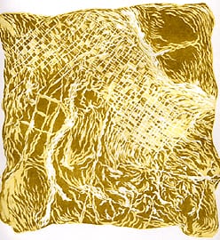
The map is a topographic image that locates us in terms of space. My visual cartography suggests our emotional and human location within the urban setting.
These maps are an abstraction of our reality, but they are not meant to be satellite images of a virtual reality that one sees in the NASA space view web site. Streets and avenues crisscross the map, the abstract level intersecting the nostalgia of urban growth with the harsh reality of human neglect.
R. V.: Trying to read the coordinates of your maps, visual metaphors and poetics brings a powerful humanistic component. Where do your ideas come from? What is the basis of your imagery?
C. L.: My conceptual development process stems from a network that I weave and build through the concerns and issues that I encounter along the way. The urban setting in which I live is the best environment for compiling testimonies that are useful for expressing my location, which is but a dot in this great urban sprawl.
My search began more than 17 years ago, when I began reproducing the shapes of icons that mark the urban landscape, such as streets, electric cables, street lights, buildings, giant construction cranes. Gradually, I began to elevate above ground level, observing the territory from the clouds and reaching a distilled urban iconography in Santiago city maps. Observed from that distance, the urban landscape hides an unfathomable amount of information and moves at a dizzy pace, yet is silent. From this vantage point, my worldview is that of a person who inhabits an urban place from the optic of the periphery.
The constant construction and de-construction of the city erases the familiar, transforming spaces and testing our capacity of memory of place. My work refers to a concept of modernization that obsessively builds towers of steel and glass, while the scaffolding of our human structure remains weak.
Construction cranes are the agents of transformation of space. Rotating high above, they may appear anywhere, great symbols of a permanent reconstruction. Frenetic train lines, buses and the absence of the human suggest a tragic metropolis.
The image of Santiago has long been present in my work, in different techniques and mediums. Images are translated into the urban places of Santiago as we imagine it, and like inhabitants of any metropolis imagine their city, tell the stories of a thousand pedestrians who leave invisible footprints in their urban wanderings.
R. V.: The series of prints of visual cartography we are exhibiting at Lehigh are basically xylography, intaglio/aquatint and lithography. Do you feel that the success of your technical evolution as a printmaker is based on those three mediums? Is this part of the visual discourse of your work?
C. L.: My professional experience as a printmaker dates only eight years. The results I have obtained are due to two fundamental pillars that form the creative base I acquired over the course of time: namely, painting and drawing. The different techniques that are present in this exhibit are fundamental to my visual discourse. Every technique I use in this exhibit is distinct.
In the Visual Cartography, Cartographic Woodcuts, and Fragments and Footprint series, the graphic and visual technical results are bi-dimensional. The nature of woodcuts is in the matrix that has richness in the grain of wood that enhances the image. That is not a characteristic of the drawing, but rather, the image is created through marks carved by the gouge. Lithographs, however, accentuate all the splendor of drawing. Lithography is an ideal introduction to printmaking because the image is created by classic drawing and painting techniques. The image is fixed upon the print’s surface in exactly the same way as if it were drawn or painted on paper.
Every idea one seeks to express graphically is subject to the method, technical possibilities and the artists’ mastery of craft. In my case, I work with the four basic principles of printmaking: printing in relief as in woodcuts, silkscreen, intaglio and lithography.
R. V.: Tell me about your working process. How does it relate to the content or meaning in your work?
C. L.: The printmaking techniques I used to produce this exhibit require a discipline, but printmaking is not the point of departure for my work. Rather, all the creative processes I have accumulated over the years have led me to printmaking. Results of the last series or subjects I explored become the starting place for new explorations and experimentation, as I look for new ways to convey meaning and symbols. One begins by de-composing in order to compose.
The hanger-jackets series emerged from an intervention I did on my smock, on which I glued brown paper silkscreened with the map of Santiago. That work developed into an installation I created in 2004 for a group exhibit called “Rehabitar” (Re-inhabit) that explored installation and three-dimensional formats. That experience brought me back to traditional bi-dimensional printmaking, and the hanger-jacket series. Also it allowed me to reflect on how matter can mutate and the analogy between body and map. My creative process was transformed by the results and iconography I experience and compile, like a domino effect.
The iconography on which this exhibit centers has its genesis and derives from my perspective as an artist who lives in a city at the periphery of South America, isolated by two natural barriers, the Pacific Ocean and the Andes Mountain range. My social condition, born in a working class Chilean family, brings to mind differences that exist in our different continents, and my experience as an artist provides a universal means to express those impressions.
R. V.: As a Latin American artist/photographer, what do you think art is, for society and for yourself?
C. L.: Art is essential for Latin American society, and all societies. Learning about and experiencing art must not be limited to a privileged few. Through art, we express ourselves, learn, and experience cultural diversity of the far corners of the globe. Artists of the past and present, through their varied views and languages, make a tremendous social and cultural contribution by focusing on particular cultural characteristics, and questioning national boundaries as set by maps.
RV: How important is teaching to you?
C.L.: I am a visual artist who works basically as a painter and printmaker, as well as muralist. As a teacher, I also feel a strong commitment – a social, cultural and civic commitment – to marginalized and poor sectors of Santiago. For over 12 years, I have conducted art and mural workshops in Conchali, Quilicura, Huechuraba, La Granja, El Bosque, working class areas where unemployment is high, drug traffic a reality, and many teenagers become parents before finishing high school.
Particularly in El Bosque, where I have taught in the municipal Casa de la Cultura eight years, I help individuals tap and nurture a creative potential that lies dormant. Many people have a creative vein that they are not able to develop due to pressing economic and social needs. In these workshops, people who have not had the possibility to study art, rediscover their creative potential. In this context creativity joins a pedagogical purpose with a social vision. As a Latin American artist, the teaching process enriches me, and I simply give back to others what I received, because I grew up a similar setting.
R. V.: The title of our exhibition is “Visualization and Global Identity.” As the curator, I see your work as an integral part of this concept. Do you see it in a global context?
C.L.: “Visualization and global identity” is an excellent synthesis of concepts represented in my work, which are realities the world over. My viewpoint is from my place in the Third World but the issues of our times – urban transformation resulting in loss of memory of place, a homogenized worldview chipping away at cultural identity – are shared in all corners of the globe. Skyscrapers tower in urban centers around the world, while on the ground level, on the map level, human development is deferred. My maps suggest a search for a route back to a shared humanity. Global identity is the great issue that is a bridge to the public that perceives my work from their own subjective context.
R. V: A map can be read in many different ways, and has many meanings in the dictionary. How should we read your maps? Or better yet, how do you yourself read them?
C. L.: Each human being is unique; therefore, how that individual perceives the map of his or her life is also unique. My reading of the map is open; these are not scientific or military maps designed for a technical purpose. These maps are visual expressions of the routes all of us follow in our daily existence and will follow in the course of our lives. Our urban wanderings produce a demarcation between the public and private spheres of our existence.
Cartographic history shows that from the earliest existence of mankind, human beings, in our eagerness to possess space and places, connect with our habitat. That is why I take the urban map and give it a different reading to offer new perspectives of our cities.